Hawkvine Side Scan Sonar D150 D450 Broadband CHIRP technology for Hydrographic and Geophysical Surveys.
D Series side scan sonar can simultaneously transmit the CW or CHIRP signal. The echo signal was send to the deck unit by towfish through the underwater cable after receiving and processing, then processed by the sonar display-control software and generate the high resolution imaging data which can be saved to OTSS and XTF formats used to replay. Chirp technology can help enhancing the detection range of this system and achieving higher resolution data in bigger range.
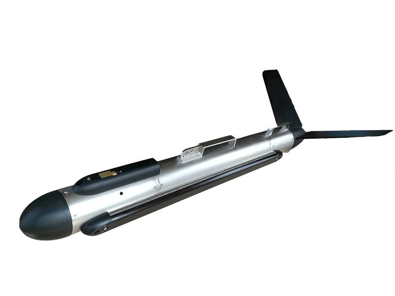
A strong stainless steel tow fish, a high strength Kevlar cable, a waterproof deck unit and the customized OTech® software are included in the sonar system which designed with ultra-low power consumption and can be powered with both AC and DC power.
With compact and portable design, the sonar is reliable & durable, and can be easily operated by a single person. It can be fixed onto the bottom or side of the boat,and also can be dragged directly to work. The towfish is designed with collision protection which effectively assure the safety of the underwater working.
OTech® software is equipped with the function of sonar image display, navigation, data recording & replay, target management & output and sensor information multi-window display. It can output the data with standard formats which can be processed with the third party processing software, and also can be customized according to the requirements.
D150 features:
• Dual simultaneous frequency
• Enhanced resolution at long range
• Broadband CHIRP technology
• Build-in sounding module
• Towfish attitude real-time display
• Towfish impact protection
• OTech® acquisition software
D150 Application:
• Hydrographic Surveys
• Geophysical Surveys
• Cable and Pipeline Surveys
• Dredging Surveys
• Pier/Harbor Wall Inspections
• AUV/ROV Integration
| Hawkvine No. | HV-D150 | HV-D450 |
| Frequency | 150kHz & 450kHz | 450kHz & 900kHz |
| Pulse Type | CW/LFM(CHIRP) |
| Maximum Range | 450m @ 150kHz;150m @ 450kHz;75m @ 900kHz |
| Beam Width | Horizontal:0.6°@ 150kHz;0.3° @ 450kHz;0.2° @ 900kHz Vertical:45° |
| Resolution(h-range) | Along track:0.01h @150kHz;0.005h @450kHz;0.003h @900kHz |
| Across track:1.25cm |
| Depression Angle | Tilted down 15° |
| Depth Rating | 1000m(316 stainless Steel) |
| Standard Towfish Sensors | roll,pitch,heading,depth,altitude |
| Towfish Size/Weight(air) | 1300mm*105mm(length*D)/29kg | 1170mm*105mm(length*D)/25kg |
| Deck Unit Size/Weight | 170mm*120mm*70mm /0.8kg |
| Power Consumption | 220/110VAC,40W | 220/110VA,30W |
| Software OTech® | Windows,NMEA 0183 Navigation Data Input,OTSS,XTF Output Data Format |
| Tow Cable | Kevlar,standard length: 50m(option);winches available |

|
|
Hawkvine Side Scan Sonar D150 D450 Broadband CHIRP technology for Hydrographic and Geophysical Surveys Images
|